What Makes the Col du Tourmalet so Special?
The original classic climb. The Col du Tourmalet was the first of the really big mountain passes used in the Tour when it was included in the 1910 route. Up to 2017, it has been used a staggering 85 times, more than any other climb. The Tourmalet is the highest paved pass in the French Pyrenees topping out 2115m making this a long climb from either side.
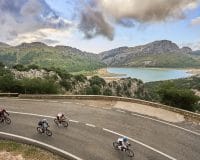
So it’s incredibly high and steeped in Tour history. Pretty good. But the Tourmalet, and surrounding climbs are stunningly beautiful and remote. There are a few roads in this part of the Pyrenees and it is common for sheep or cattle to wander onto this famous cycling spot. In the summer, the roads are full of cyclists from around the world, find someone of your own pace and you’ll spend such a long time climbing that you could be best friends by the summit!
The season is dependent on weather but it’s usually late May through to late September. As with everywhere in the mountains, the weather can be very changeable. It is not unusual for it to be raining and cold one day and then sunny and hot the next, as anyone that’s ridden the Etape can testify.
Col du Tourmalet Location
There are only a few towns in the mountains, the best place to stay is at the bottom of the climb in Luz Saint Sauveur. Situated in the heart of the Pyrenees, one of the best parts of a trip to the Tourmalet is the proximity of so many classic climbs. In the Alps, from one base you can only ride a handful of famous climbs but from Luz Saint Sauveur you are close to the Aspin, Aubisque, Luz Ardiden, Soulor, Hautacam, Hauquette & Bouchard – more than enough to keep you busy over a long weekend.
Luz Saint Sauveur is at the base of the Tourmalet on the east. There is everything you need in town including a good bike rental shop (Ardiden Velos), a few good restaurants, a supermarket and a petrol station. There are also a couple of bars that are packed full of cyclists celebrating their rides each day. This is a really enjoyable part of the trip, drinking cold beers in the sun with cyclists from all over the world, all ecstatic to be in such an amazing place.
To the west of the Tourmalet, there aren’t any towns for some distance. Head towards the Aspin and you will get to the Lac de Payolle with a large camping park and a couple of cafes. Once you get over the Aspin there are more options, the major town is Arreau or you can continue over the Peyresourde to the major, and the charming, mountain spa town of Luchon.
Stay in – Luz Saint Sauveur
Recommended Bike Friendly Hotel – Hotel le Montaigu
Nearest airports to Col du Tourmalet – Tarbes / Lourdes (LDE) is 45 mins away. There are more flights to Toulouse (TLS) which is just over 2 hours away. Avoid arriving during rush hour as the traffic getting out of Toulouse can be slow.
The Climb
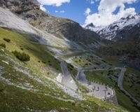
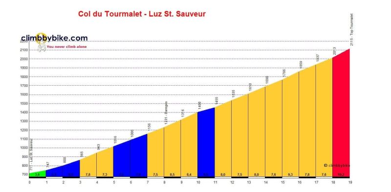
From Luz Saint Sauveur: It’s a gentle roll out of town with an easy first kilometre. The climb starts along a stream and the road is quite wide and busy at this stage (this is the only road connecting this part of the Pyrenees). There are markers every kilometre, telling you how far to the top and the gradient of the next section. After 7km of fairly steady, 6 to 7% inclines, you go through the small town of Bareges and then the climb gets more remote. Not too long after town you hit a ski station and the first hairpins, and from here the climb is stunning. For kilometres, all you can see is the road snaking down the valley, jagged peaks and animals grazing. The gradients start to get steeper (8 to 9%) and then inexplicably the kilometre markers disappear with 5km to go. Near the top, the scenery changes again. You are far above the tree line and the lush pastures change to rocky views and even steeper gradients (the last km is over 10%). The climb finishes with a sharp hairpin and then the welcome sight of the famous monument and cafe at the top.
Col du Tourmalet Distance – 19km
Average Gradient – 7.4%
From Sainte Marie de Campan: The official start of the climb is when you turn onto the D918 but there is a long false flat to get you to this point. There is a fairly large ski resort on this side of the Tourmalet, so the road can be slightly busier and it feels slightly less remote than the Luz ascent. The first 5 km are fairly comfortable and then the gradient increases to stay above 7% all the way to the top. The climb stays in the trees for a long time which can keep it very hot in the middle of summer, there is some relief from a couple of short tunnels. As the road goes over the treeline you hit a slightly ugly ski resort by which time you are close. The final couple of kilometres are filled with hairpins until you hit one last left turn and see the summit open up in front of you.
Distance – 17.2km
Average Gradient – 7.4%

Other Climbs in the Area
The classic Tour de France stage would go in either direction from Pau to Luchon. Starting from Pau, the climbs would be:
- Col d’Aubisque – 16.6km at 7.2%
- Col du Soulor – 13km at 7.1%
- After the Tourmalet, Col d’Aspin – 12.8km at 5%
- Hourqette d’Ancizan – 10.3km at 7.8%
- Col de Peyresourde – 10km at 6.6%
- There are some other great climbs close to Luz Saint Sauveur which are all dead ends – these all work as short rides on the first / last day or as finishing climbs to a route. These include:
- Luz Ardiden – 14.7km at 6.9%
- Hautacam – 17.3km at 6.8%
- Col de Bouchard – 31km at 5.1%
Sportives Featuring the Tourmalet
The mighty Marmotte Pyrenees takes on the Tourmalet not just once, but twice. The sportive, on the August bank holiday weekend, is probably the hardest of the year. Starting in Luz Saint Sauveur, the route goes over the Tourmalet and then Aspin before coming back over the Hourquette & the Tourmalet again. From Luz, riders head to Argeles Gasozt before the final climb of the Hautecam. That’s well over 5,000m of climbing.